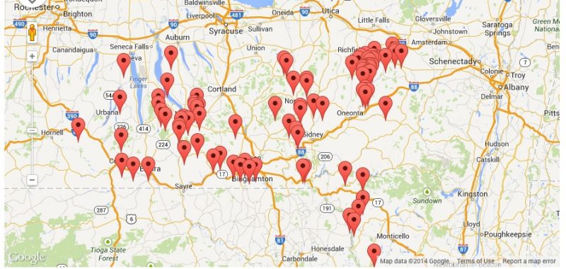
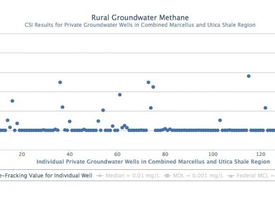
CSI’s Regional Baseline Initiative seeks to collect scientifically credible baseline water quality data related to “hydrofracking” and make these data available to the public. [/quote]
The new technology of horizontal drilling combined with high volume slick water hydraulic fracturing or “hydrofracking” has opened up the Marcellus and other shale deposits around the world as a source of natural gas. It has also raised serious concerns about environmental risks to water, air and forests as well as long-term impacts on rural communities and economies.
The Community Science Institute has responded to these risks to water by launching the Regional Baseline Initiative to make baseline testing data available to the public and establish baselines for New York’s groundwater and streams. Our online database of regional groundwater quality contains baseline test results from hundreds of private wells and the Red Flag monitoring program works with volunteers who are actively collecting baseline data for dozens of small streams and creeks across New York.
The regional groundwater database is an important addition to CSI’s existing database of certified stream and lake data. The groundwater portion of the database contains certified test results from comprehensive baseline tests performed by CSI since 2009. This database represents the largest set of certified water quality data related to “hydrofracking” for private wells in New York, such as methane concentrations shown in the scatterplot on the right. Keeping the database free and open to the public allows residents and agencies to have access to results you can trust about baseline water quality.
CSI has tested over 300 private wells for baseline analysis since 2009 and asks these homeowners for their permission to enter their results anonymously into our database. Doing so is optional and over 80% of clients have responded positively to our request. In order to protect homeowners’ privacy, drinking water wells are mapped to 1-mile grid squares and not to specific addresses, as shown on the map.
There are many who together made this project possible: Abner X. Figueroa, CSI’s Senior Web Developer, who has been developing this complex, innovative database since 2010; the Park Foundation for their financial support of the Regional Baseline Initiative; and all of our clients who contributed their data.
In 2010, CSI began recruiting and training groups of volunteers to partner with our certified lab to monitor streams and lakes in the Southern Tier with the Red Flag Monitoring program.
Red Flag stream monitoring with volunteers is an effective and affordable way to collect high-quality data on area lakes and streams. The goal of this type of the Red Flag Monitoring program is to establish baseline water quality for parameters related to shale gas wells, specifically “hydrofracking”; and should “hydrofracking” begin in New York, to document whether or not impacts on streams and lakes occur as a result.
Red Flag monitoring places a focus on small streams and creeks for which little to no water quality data exists. Red Flag monitoring has the potential to document both catastrophic contamination events such as chemical spills and gradual degradation that could result from small impacts accumulating over a period of months or years.
Visit the Red Flag Monitoring page for more details.
Dear CSI Volunteers, Friends, and Supporters, The board
This summer CSI will again be hosting fun, water science education events